

SaRFIIS
Identification of the mountain road sections at risk of landslides with the greatest impact from service interruptions on the Territory
Scheda del progetto


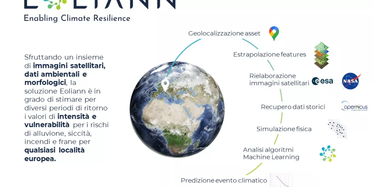
The Eoliann project, with the support of the Links Foundation, aims to estimate the landslide risk across the entire territory of the Piedmont region and to evaluate the impact that this type of risk can have on the road infrastructure. To achieve this objective, physical and data-driven modeling techniques (Artificial Intelligence) will be used based on the use of satellite images and data from different sources, which allow changes in meteorological, hydrological and environmental conditions to be better taken into account. The main objective is to provide support to the managing bodies and competent authorities in prioritizing interventions on the road sections (or logistics chains) with the greatest climate risk and the highest potential economic losses. After the research phase, the models will be adapted to a specific context and validated with the collaboration of the Piedmont Region (end user).
Contacts:
Giacomo Di Fuccia – Project Coordinator
giacomo.difuccia@eoliann.com
Federico D’Albenzio – Business Developer
federico.dalbenzio@eoliann.com
+39 3423386840
The main ambition of the project is to provide, on the one hand, a unique tool for assessing the landslide risk of the territory and the vulnerability of infrastructures, and on the other to share all the information necessary for the user to understand and contextualize the values and the indices exposed by the models. Furthermore, despite the focus on the Piedmont Region, it will be possible, thanks to Artificial Intelligence techniques, to develop a product that is easily scalable and generalizable on a national and European scale.
In addition to the technologies already in use, the use of equipment for both aerial and terrestrial data collection, the use of economically sustainable sensor networks that allow the creation of "sensor clouds" on sites at risk, but also the use of an emerging technology such as augmented reality, which will allow the operator to be aware of critical areas while maintaining a safe distance for his own safety.
The project generates impacts in various areas:
Scientific thanks to the development of research on techniques for mitigating the effects of climate change, the use of satellite data and the exploitation of advanced machine learning techniques;
Economic/technological, increasing operational efficiency in the management of road infrastructures and leading to the development of new technologies and business processes, as well as the efficiency of public resources thanks to a better allocation of resources and working times;
Social/environmental to bring to attention the importance of reducing the isolation of mountain communities, preventing environmental damage, increasing safety and spreading awareness towards more sustainable behaviours, as well as valorising local resources and strengthening of the local production chain.