
Digital Twin – The City of Turin in Virtual Form
A Twin for the Municipality – Spoke 1 NODES and Turin’s Digital Twin
Within Spoke 1 NODES, starting from the work of the Interuniversity Department of Sciences, Design and Territorial Policies of the Politecnico di Torino and the University of Turin, the Digital Twin of the City of Turin is being developed.
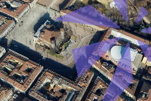
The Digital Twin is (re)constructed from 32,000 photograms and LiDAR scans, precise to the centimeter. This enormous amount of data, collected both from the ground and from above, is combined to create an extremely realistic three-dimensional model, accurately reflecting the city’s appearance and proportions in great detail.
Turin’s digital twin will be used by the city administration to quickly understand urban needs and to effectively plan both urgent interventions and future policies and projects. The model is indeed an ideal tool to support decision-makers, serving the citizens.
Currently, the model can be explored at the Automobile Museum of Turin through the “Spazio Futuro” initiative, which provides insight into ongoing transformations in sustainable mobility and possible future trajectories.
The potential applications are countless, but currently, with specific technical support from Politecnico, the City of Turin has been able to identify and act on two initial, major areas: mobility and urban green space management.
Thanks to the model’s precision, it is possible to analyze green areas, streets, sidewalks, and signage in great detail. Once the condition of green spaces or road surfaces is clear, priorities for action in a given area can be identified, reducing time and costs while facilitating coordination among the various stakeholders, avoiding overlaps, and efficiently planning interventions both on the surface and on underground infrastructure (fiber, electricity, stormwater and sewage systems, etc.).
The City has already effectively used the Digital Twin to quantify upcoming green space maintenance, greatly simplifying management for the allocation of future work.
The Digital Twin tool is not only useful for large urban centers; it can also be applied to smaller towns or adapted for other sectors, such as agriculture or territorial management, including civil protection purposes.
Researchers and companies can contact the research group for more information:
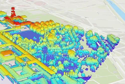
1. Immagine multispettrale nadirale 2. Il modello su San Salvario 3. Dati termici e nuvola dati 4. Nuvola di punti del Castello del Valentino